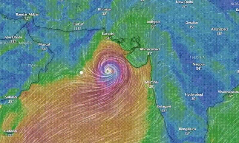
The Pakistan Meteorological Department (PMD) has announced that despite the eye of the storm likely missing Karachi and parts of Balochistan, Cyclone Biparjoy is anticipated to maintain its intensity and severity as it heads towards landfall on June 15. As preparations for the approaching cyclonic storm commence, Chief Minister Murad Ali Shah has identified the vulnerable areas in the southern region of Sindh, including districts such as Sujawal, Badin, Thatta, and certain buildings in Karachi.
According to the PMD, the extremely severe cyclonic storm has moved north-northwestward over the past 24 hours, currently positioned approximately 550km south of Karachi, 530km south of Thatta, and 650km southeast of Ormara. Chief Meteorologist Dr. Sardar Sarfaraz stated that while the major mass of the cyclonic storm is projected to hit the Kutch area of Indian Gujarat, its outer periphery is expected to affect lower Sindh. The system is likely to bring high winds, dust storms, thunderstorms, and heavy to extreme rainfall to areas including Sujawal, Thatta, Badin, Mirpurkhas, Tharparkar, and Umerkot, starting today.
The cyclonic storm is anticipated to maintain its form after making landfall. The maximum sustained surface winds generated by the cyclone are estimated to be around 140-150kmph, reaching up to 170kmph near the eye of the storm. Sea conditions around the storm center are reported to be phenomenal, supporting the severity of the system.
The PMD predicts that Cyclone Biparjoy will track further northward until the morning of June 14, then recurve northeastward and make landfall between Keti Bandar in Southeast Sindh and the Indian Gujarat coast on the afternoon of June 15 as a very severe cyclonic storm. From June 14 to 16, Karachi, Hyderabad, Tando Muhammad Khan, Tando Allayar, Shaheed Benazirabad, and Sanghar districts are expected to experience dust and thunderstorms, along with heavy rainfall and squally winds of 60-80kmph. Authorities have warned that squally winds may cause damage to vulnerable structures and advised against venturing into the open sea until June 17 due to rough conditions and high tides.
In response to the approaching storm, the National Disaster Management Authority (NDMA) and the Meteorological Department have advised shipping corporations, fishermen, farmers, and residents near dams and rivers to avoid the open sea until the system passes. The Sindh government has declared an emergency in major hospitals of the Karachi division and ordered medical staff to ensure their availability during the storm. Evacuation efforts are underway in vulnerable areas, with coordination between the district administration, navy, and army. Control rooms have been set up, and villagers in Keti Bandar have already been relocated to safer locations.


